GEOGRAPHY
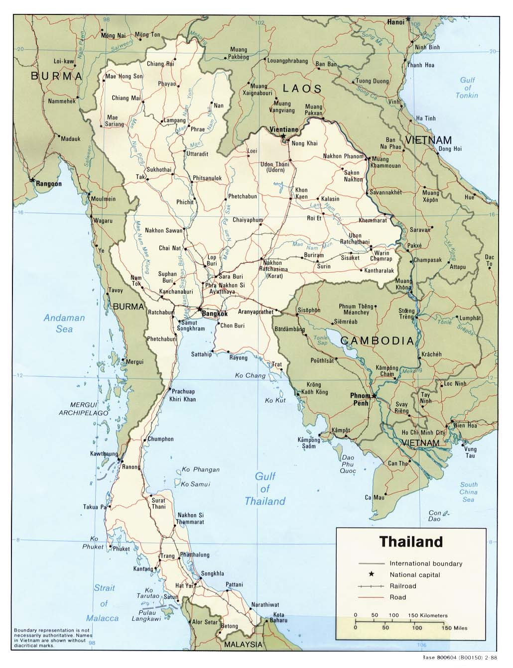
The kingdom of Thailand lies in the heart of Southeast Asia, making it a natural gateway to Indochina, Myanmar and Southern China. Its shape and geography divide into four natural regions : the mountains and forests of the North; the vast rice fields of the Central Plains; the semi-arid farm lands of the Northeast plateau; and the tropical islands and long coastline of the peninsula South.
The country comprises 76 provinces that are further divided into districts, sub-districts and villages. Bangkok is the capital city and centre of political, commercial, industrial and cultural activities. It is also the seat of Thailand's revered Royal Family, with His Majesty the King recognised as Head of State, Head of the Armed Forces, Upholder of the Buddhist religion and Upholder of all religions.
Thailand is a constitutional monarchy with His Majesty King Bhumibol Adulyadej, or King Rama IX, the ninth king of the Chakri Dynasty, the present king. The King has reigned for more than half a century, making him the longest reigning Thai monarch. Thailand embraces a rich diversity of cultures and traditions. With its proud history, tropical climate and renowned hospitality, the Kingdom is a never-ending source of fascination and pleasure for international visitors.
Location: Southeastern Asia, bordering the Andaman Sea and the Gulf of Thailand, southeast of Burma
Geographic coordinates: 15 00 N, 100 00 E,
Map references: Southeast Asia
Area:
total: 514,000 sq km
land: 511,770 sq km
water: 2,230 sq km
Area—comparative: slightly more than twice the size of Wyoming
Land boundaries:
total: 4,863 km
border countries: Burma 1,800 km, Cambodia 803 km, Laos 1,754 km, Malaysia 506 km
Coastline: 3,219 km
Maritime claims:
continental shelf: 200-m depth or to the depth of exploitation
exclusive economic zone: 200 nm
territorial sea: 12 nm
Climate: tropical; rainy, warm, cloudy southwest monsoon (mid-May to September); dry, cool northeast monsoon (November to mid-March); southern isthmus always hot and humid
Terrain: central plain; Khorat Plateau in the east; mountains elsewhere
Elevation extremes:
lowest point: Gulf of Thailand 0 m
highest point: Doi Inthanon 2,576 m
Natural resources: tin, rubber, natural gas, tungsten, tantalum, timber, lead, fish, gypsum, lignite, fluorite
Land use:
arable land: 34%
permanent crops: 6%
permxnent pastures: 2%
forests and woodland: 26%
other: 32% (1993 est.)
Irrigated land: 44,000 sq km (1993 est.)
Natural hazards: land subsidence in Bangkok area resulting from the depletion of the water table; droughts
Environment—current issues: air pollution from vehicle emissions; water pollution from organic and factory wastes; deforestation; soil erosion; wildlife populations threatened by illegal hunting
Environment—international agreements:
party to: Climate Change, Endangered Species, Hazardous Wastes, Marine Life Conservation, Nuclear Test Ban, Ozone Layer Protection, Tropical Timber 83, Tropical Timber 94 signed, but not ratified: Biodiversity, Climate Change-Kyoto Protocol, Law of the Sea
Geography—note: controls only land route from Asia to Malaysia and Singapore